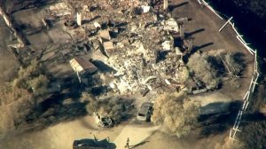
The death toll linked to the devastating Woolsey Fire rose to three Wednesday after authorities confirmed the discovery of a fire victim inside a razed residence south of Agoura Hills.

Cadaver dogs found the body among the rubble of a home burned to its foundation at about 6 a.m. in the 32000 block of Lobo Canyon Road, in an unincorporated area at the northwest edge of the Santa Monica Mountains, Los Angeles County Sheriff’s Department officials said.
Authorities responded to the residence to conduct a welfare check on a man who lived there and hadn’t been accounted for since the blaze destroyed his home, the agency said in a news release.
Investigators said it’s unclear if the body recovered belongs to that person, because the victim was burned beyond recognition.
But family members told KTLA they’re positive the home’s resident, 73-year-old Alfred Deciutiis, is the deceased victim. They said he was a retired physician who had practice in Southern California for more than 40 years.
Coroner’s officials are still working to positively determine the person’s age, gender, race and cause of death.
2 Previous Victims Still Unidentified

The fire was already linked to two deaths in Malibu.
The badly burned bodies were discovered Nov. 9 in an SUV found on Mulholland Highway.
Authorities do not believe the victims lived in the area.
“Those people have been accounted for,” L.A. County Sheriff’s Homicide Bureau Sgt. Guillermo Morales said. “We think they were trying to evacuate, and we kind of know who they might be, but we’re waiting for the coroner to do the identification.”
Another Flare-Up Wednesday
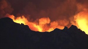
Meanwhile, flames from the more than 153-square-mile Woolsey Fire flared up again Wednesday morning in the Santa Monica Mountains, this time in the hills above Point Mugu.
Aerial video from Sky5 showed large flames burning along a brush-covered hillside. The flames had mostly subsided by 6:30 a.m., just after the sun came up.

A flare-up Tuesday burned about 1,000 acres near Lake Sherwood, prompting residents of Lake Sherwood and Hidden Valley to evacuate their homes. An interactive map provided by Cal Fire indicates which areas of L.A. and Ventura counties remain under evacuation orders.
The Woolsey Fire scorched about another 740 acres on Wednesday, its seventh day, while containment rose to 52 percent by the evening, L.A. County fire officials said.
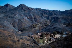
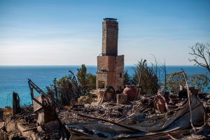
About 504 structures have been destroyed in the fire, Cal Fire estimated Wednesday, up from 483 the day before.
Another 96 buildings were damaged, while 57,000 remain threatened.
Nearly 4,000 firefighters are still attacking the blaze, which has been linked to two deaths in Malibu. Three firefighters have also been hurt, officials said, but the extent of their injuries was unclear.
The cause of the fire is still under investigation.
L.A. County Evacuations
While some areas of Los Angeles County were being repopulated, evacuation orders remained in effect for the following areas:
- Remaining areas of Topanga (parts of Topanga that are reopened are indicated below)
- The Malibu Colony neighborhood and Civic Center area
- Portions of Westlake Village
- Unincorporated areas of L.A. county directly affected by the fire
Meanwhile, al evacuations were lifted Wednesday in Calabasas, the City tweeted just after 11:30 a.m.
CITY OF #CALABASAS – No Evacuation Orders in place for the entire City of Calabasas from the #woolseyfire All residences and businesses can now be lawfully occupied. @LACoFDPIO @LASDHQ @LHSLASD
— City of Calabasas (@CityofCalabasas) November 14, 2018
In Malibu, some residents were also allowed to return home Wednesday afternoon.
The following areas were reopened to residents only at 2 p.m.: Pacific Coast Highway from Carbon Canyon Road (east) to Webb Way (west), the neighborhoods of Serra Retreat and Sweetwater Mesa, areas from the eastern city limits to Webb Way and from the ocean to the northern Malibu city limits.
Officials moved the checkpoint verifying residency from Pacific Coast Highway and Coastline Road to Pacific Coast Highway and Carbon Canyon Road in the City of Malibu. Only residents who live in the repopulated areas west of Carbon Canyon Road will be permitted to enter that area, while the area west of Webb Way will remain closed.

Other residents being allowed to return home include those in unincorporated Agoura in the following areas:
- Kanan Road from Cornell Road (north) to Malibu View Court (south)
- Southeast of Kanan Road to include the Saratoga Hills neighborhood
- Cornell Road from Kanan Road, north of Wagon Road
However, Kanan Road south of Agoura Road is open only to Malibu View Court, not to the coast, according to Cal Fire and CHP officials.
Other areas of L.A. County no longer under an evacuation orders include:
- Northern section of unincorporated Topanga, including north of Viewridge Road, south of the Los Angeles city limits, east of Topanga Canyon Boulevard and west of Double Ranch Road or Santa Maria Road
- Malibu areas including along Pacific Coast Highway, west of Coastline Drive and east of Carbon Mesa Road
Evacuations were lifted from the ocean to the Malibu city limits with the exception of the following areas, where there are full closures:
- Tuna Canyon Road and Pacific Coast Highway. Evacuation orders still in effect for neighborhoods north of PCH and Tuna Canyon Road
- Topanga Canyon Boulevard. Evacuation orders remain in effect for neighborhoods north of PCH and Topanga Canyon Boulevard
- Rambla Pacifico Drive 400m north of PCH
For a full list of evacuations and the latest information on orders in L.A. County, visit www.lacounty.gov/woolseyfire.
.@LASDHQ just re-opened PCH at Topanga. Topanga remains shut down. #WoolseyFire @KTLA pic.twitter.com/MAOlaZBkZx
— mark mester (@mester_mark) November 14, 2018
Ventura County Evacuations
For the latest information about evacuations in Ventura County visit www.vcemergency.com.
Ventura County Fire Chief Mark Lorenzen said more than 50,000 people remain evacuated in his county due to the blaze.
Evacuation orders were lifted for homes in the Lake Sherwood community north of the lake and south of Potrero Road. That includes homes along Lake Sherwood Drive, Stone Creek Court, Baybrook Court, David Lane, Ravensbury Street, Cricketfield Court, Trentham Road, Cal Fire officials reported.
Road closures that remain in place:
- Potrero Road at Stafford Road
- Potrero Road at Wendy Drive
- Westlake Boulevard at Carlisle Road
Disaster Aid Teams on Scene
Officials with the Federal Emergency Management Agency (FEMA) and staff from L.A. County’s Department of Mental Health have responded to the fire area and were working to register those affected for disaster aid and other forms of assistance.
Emergency aid staff will be wearing FEMA attire and carry a FEMA photo ID, which residents should ask to see to confirm they are speaking with a qualified individual.
Those impacted could be eligible to receive grants for temporary housing and home repair, or qualify for a low-interest disaster loan.
Residents and business owners can begin applying for assistance online at www.DisasterAssistance.gov or by calling 800-621-3362 or 800-462-7585.
People whose mental health has suffered as a result of the fire can also get support by calling the Disaster Distress Helpline at 800-985-5990 or texting “TalkWithUs” to 66746.
KTLA’s Cindy Von Quednow and Marissa Wenzke contributed to this story.
Correction: A previous version of this story incorrectly identified the area where the third fire victim’s body was found.
#LASD Governor @GavinNewsom stopped by to show support to the first responders of the #WOOLSEYFIRE at one of the many meetings that happen throughout the day to discuss repopulation and opening roads. He was also genuine enough to take a picture with our very own PIO’s. pic.twitter.com/4Pi6yYpEOU
— LA County Sheriffs (@LASDHQ) November 15, 2018


