A series of storms forecast to drench Southern California during the first week of the new year could potentially provide a taste of what’s in store for the region this winter amid a possible record-setting El Niño, according to a NASA climatologist.

Forecasters predicted this round of wet weather could dump as much as 6 inches of rain on parts of the drought-stricken region while increasing the risk of flooding and mudslides.
The initial storm would drop between 0.25 and 0.75 inches of rain in the Southland, with the potential for 2 to 4 inches of snow in mountain elevations above 6,000 feet.
The first system will taper off on Monday before a second, stronger storm hits the area on Tuesday, bringing with it a steady torrent of widespread rain and brief periods of “high intensity” rainfall, according to the weather service’s latest forecast.
The intense rain prompted forecasters to warn of the threat of flash flooding, as well as mud and debris flows, in recent burn areas.
Mayor Eric Garcetti joined officials around the region Sunday in asking community members to prepare their homes and be ready to evacuate if need be.
“This storm is real and it’s coming. You may save your property, and you may save your loved ones and your own lives,” Garcetti said at an evening news conference.
Coastal and valley areas were expected to see 1 and 2 inches of precipitation, while the storm could dump 2 to 4 inches of rain in Southern California’s foothills and mountains.
Tuesday’s system also had the potential to create winter storm conditions above 7,000 feet, with predicted snow accumulations of 1 to 2 feet.
Additional storms were forecast in the region later in the week, between Wednesday and Friday. The snow levels could drop to 4,000 feet amid the colder systems, potentially impacting Interstate 5 near the Grapevine, according to the weather service.
Brief heavy downpours, isolated thunderstorms and gusty winds with the capability to down trees and power lines were also possible later in the week, forecasters warned.
In total, the first major storm system of the year was expected to dump about 6 inches of rain in and around Los Angeles, about double the normal amount of rainfall in the L.A. area for January, the Los Angeles Times reported.
With the area experiencing below-average rainfall totals in the previous two months, Bill Patzert, a climatologist with the NASA’s Jet Propulsion Laboratory, told the newspaper the effects of the storms should be “a pretty dramatic whiplash.”
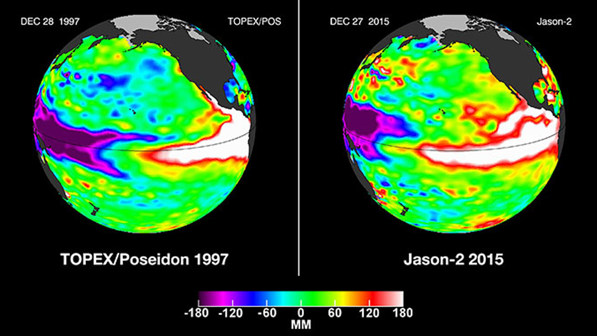
The storms were forecast as an El Niño weather pattern continued to grow, according to a NASA blog post.
An image of the current El Niño showed “unusually high sea surface heights along the equator in the central and eastern Pacific: the signature of a big and powerful El Niño,” NASA stated in the post.
Experts have compared it to the powerful, record-setting 1997 event, which has been blamed for 17 deaths and caused more than $500 million worth of damage in the state.
Patzert, who previously warned of a potential Godzilla El Niño, told the Times the downpours could provide a taste of what Southern California likely would experience this winter.
“I think this is the beginning of the beginning,” he said.
El Niño typically peaks in California during the first three months of the year, according to the climatologist. He predicted in mid-November that the state would likely face “mudslides, heavy rainfall, one storm after another like a conveyor belt” once the wet weather began.
Still, the rain likely won’t be enough to end the state’s yearslong drought, according to Patzert.
“Over the long haul, big El Niños are infrequent and supply only seven percent of California’s water,” he stated in the NASA blog post.
While El Niño has created “weather chaos” around the world in the last few months of 2015, its impacts in the United States were not expected to be felt until this year, according to NASA.
In the southern U.S., the shift in weather pattern would usher in a period of relatively cool and wet conditions; the northern states, meanwhile, could expect relatively warm and dry conditions over the next several months.
KTLA’s Ashley Soley-Cerro contributed to this report.


