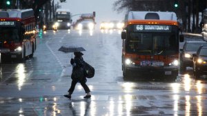
The second of three storms making their way across Southern California brought rain and snow to the region throughout the day Friday, and has promoted multiple road closures because of flooding.
A flash flood warning was issued for the Sand, Sage ad Calgrove burn areas in Los Angeles County until 3:15 p.m. Friday, according to the National Weather Service.
In addition, a severe thunderstorm warning was issued f in Duarte or western Orange County, according to the weather service.
The California incline has been closed because of mud and debris falling from the bluffs, Santa Monica Police Chief Jacqueline Seabrooks tweeted.
All canyon roads in Malibu were closed because of rock slides, water runoff and tree debris, according to California Highway Patrol.
Pacific Coast Highway was also closed in both directions at Sunset Boulevard because of downed power lines, according to the City of Malibu and Cal Trans.
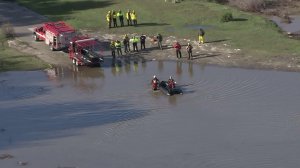
The Sepulveda Basin in Sherman Oaks was closed because of flooding and was reopened about 6:40 p.m.
Several people were rescued from the basin Friday afternoon and the area was evacuated, according to the Los Angeles Fire Department.
Flooding was also reported in Santa Clarita’s Sand Canyon neighborhood, where a brush fire raged last summer.
Friday’s storm was expected to be even stronger than Thursday’s, which brought just under one inch of rain to downtown Los Angeles.
Snow levels are expected to plummet with this, the coldest of the three storms.
Forecasters are calling for snow down to about 4,000 feet by Friday night. Drivers along the Grapevine could see snow flurries late Friday, according to the National Weather Service.
Higher mountain elevations could see significant snowfall along with powerful winds gusting to 60 mph at times, the weather service stated.
Snow Summit and Bear Mountain closed Friday due to “powder overload, winds and road conditions,” Big Bear Mountain Resort tweeted. The resorts are expected to reopen on Saturday.
Los Angeles County Sheriff’s officials were warning residents of an extreme risk of avalanche in the Wrightwood area of the Angeles National Forest. Officials believe this will be an issue during the weekend and into next week.
There is also a slight chance of thunderstorms producing heavy downpours and waterspouts.
A yellow alert remained in place for residents below the Fish Fire burn areas. K Rails were in place to protect neighborhoods for a second day of heavy showers.
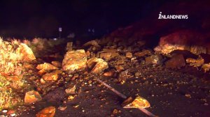
In Lytle Creek, a rockslide that occurred just before midnight had covered a portion of Lytle Creek Road.
California Highway Patrol officials closed the road near South Fork Road until the boulders could be cleared.
The southbound lanes had reopened by 5:30 a.m.
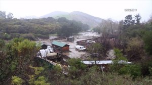
Multiple people were rescued from the El Capitan Canyon Resort and Campground in Santa Barbara County when the area was flooded with storm runoff, according to the local fire department.
About a dozen campers were trapped In cabins or cars, the Los Angeles Times reported. The area is susceptible to flooding after the Sherpa fire last year, according to the newspaper.
A third storm, likely the strongest of the three, is still waiting in the Pacific and is expected to arrive late Saturday and bring showers through Monday. The heaviest rainfall is expected to fall during the day Sunday, according to the Weather Service.
High surf advisories and warnings are in place along the Los Angeles and Ventura county coasts where surf is expected to build to between 10 and 16 feet by late Friday into Saturday.
A coastal flood advisory has been issued from 3 a.m. Saturday through 6 a.m. Sunday.
The three storms combined are expected to bring between three and six inches of rain to the coastal and valley areas, with up to 9 inches possible for some foothills and mountains.
Flash Flood WARNING for Sand, Sage, Calgrove burn areas in LA Co. until 2PM. Rock/mudslide expected on canyon rds #CAStorm #CARain pic.twitter.com/TxNXIO10fF
— NWS Los Angeles (@NWSLosAngeles) January 20, 2017
TRAFFIC SAFETY ALERT California Incline has been shutdown until further notice due to mud and debris from the bluffs falling on the Incline.
— Kenneth Semko (@SantaMonicaCoP) January 20, 2017
#TrafficAlert #LATraffic #Flooding #shermanoaks Sepulveda Basin is closed due to flooding. Do not drive flooded streets. Avoid this area.
— LAFD Talk (@LAFDtalk) January 20, 2017
TRAFFIC ADVISORY UPDATE IN MALIBU: ALL CANYON ROADS ARE CLOSED DUE TO ROCK SLIDES/WATER RUNOFF/TREE DEBRIS FOR UNKNOWN DURATION
— CHP PIO – LA County (@CHPsouthern) January 20, 2017


