In its fifth day, the battle against the 223-square-mile Thomas Fire — which forced the evacuation of more than 87,000 people in Ventura and Santa Barbara counties — was aided by more moderate weather Friday, authorities said.
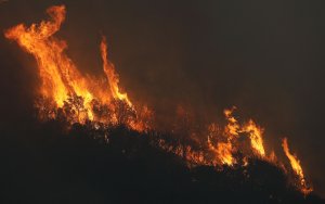
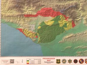
The blaze first broke out late Monday in the Santa Paula area before being swept by Santa Ana winds toward the city of Ventura, and later, north toward Santa Barbara County and the coastline as well as toward the Fillmore area.
On Friday, winds were milder and allowed more helicopters and air tankers to drop water and fire retardant, according to an afternoon news release from Cal Fire.
Some evacuation orders were lifted Friday. Fire officials announced the following, effective as of 4 p.m.:
- City of Ventura: All mandatory and voluntary evacuation orders have been lifted in the city of Ventura with the exception of the area north of West Main Street and east of State Route 33, commonly known as Ventura Avenue, and all neighborhoods north of Poli and Foothill Road.
- City of Santa Paula: All mandatory evacuation orders have been lifted in the city of Santa Paula for the areas north of State Route 126 from the west end of the city east to Willard Road and north to Bridge Road.
- Unincorporated Areas between Ventura and Santa Paula: All mandatory evacuation orders have been lifted north of Foothill Road from Santa Paula to Kimball Road in Ventura.
Firefighting efforts had been complicated by changing wind directions, and the 143,000-acre wildfire was still just 10 percent contained by Friday evening.
The fire is threatening 15,000 structures and has already destroyed 400 and damaged 81, officials said Friday morning. At the latest news conference, which was held 6 p.m. Friday, authorities said the fire had destroyed about 158 single-family homes in the city of Ventura and damaged approximately 104 residences.
The night before, fire officials said the blaze had destroyed nearly 440 structures, with over 400 in just Ventura alone.
It is still unclear how many of these buildings are homes, and authorities emphasized they’re still in the process of surveying the damage.
#ThomasFire – The fire continues to grow to the north and west towards Santa Barbara County.
— VCFD PIO (@VCFD_PIO) December 8, 2017
The number of damaged or destroyed structures could grow, as fire and rescue crews are still assessing the damage.
More than 87,000 people were under an evacuation order, the Ventura County Fire Department said Friday afternoon.
After experiencing wildfires before, one homeowner who lost her Ventura County home told KTLA she didn’t expect the Thomas Fire to leave behind so little.

“When we left, we’ve been through so many fires before, that [I thought] there be some stuff left. But no, there’s nothing,” she said, looking over the piles of debris and rubble where her home once was. “And now I’m kicking myself for all the stuff I didn’t think to pack. But it happened so quickly.”
Santa Barbara County Sheriff Bill Brown warned residents living in an area near the Santa Barbara-Ventura county line to be “ready to go at a moment’s notice” Thursday evening.
The fire — for which Gov. Jerry Brown previously declared states of emergencies in Ventura and Santa Barbara counties — is burning on the north and east sides of the 150 Freeway as well as on the west side of the 33 Freeway, officials said.
President Donald Trump has declared an emergency in the state and has ordered federal assistance from the Department of Homeland Security and the Federal Emergency Management Agency for fire relief efforts, the White House announced Friday.
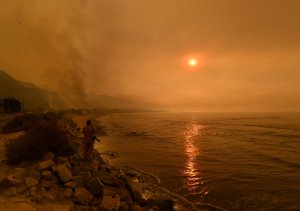
(Credit: Mark Ralston/AFP/Getty Images)
The Thomas Fire made its way to the 101 Freeway just along the coastline near the Ventura-Santa Barbara county line, where thick blankets of smoke and the orange glow of the blaze has made for an eerie scene over the shoreline.
Coastal communities from Ventura to Santa Monica are expected to see heavy clouds of smoke being blown in their direction Friday, according to the National Weather Service.
Local water officials have issued a boil-water advisory for some Ventura County residents due to decreases in water pressure and supply as a result of power outages. Those living in the upper Ojai Valley, Casitas Springs, Foster Park and parts of the city of Ventura should boil water for at least one minute before using it for cooking or drinking.
The Ventura Police Department has issued a curfew beginning at 10 p.m. and ending at 5 a.m., but that order was amended Friday evening.
NEW at the #ThomasFire -Telephone Information Line has been established for the public :: 805-465-6650
— VCFD PIO (@VCFD_PIO) December 8, 2017
Just over 3,500 firefighters are battling the blaze, along with 21 helicopters and 544 engines, officials said.
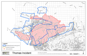
Mandatory Evacuations for Ventura County (as of Friday morning):
City of Santa Paula – boundary of Bridge Road north to Thomas Aquinas, Dickenson Ranch Road east to Santa Paula Creek
Santa Paula unincorporated area – east of Santa Paula Creek, north of highway 126, west of Hall Road to Timber Canyon Road
City of Ventura – North of Foothill Road from Kimball Road west to Poli Street
City of Ventura – North Poli Street from Hall Canyon west to Cedar Street
City of Ventura – north of Main Street from Seaward Avenue to Hwy 33 (includes entire Ventura Avenue area)
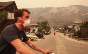
Oak View – Boundary of Hwy 33 east to Creek Road, Creek Road north to Fairview Road
Meiners Oaks – North of E. El Roblar between Rice Road and Hwy 33
Entire Community of Casitas Springs – Evacuate to Ventura County Fairgrounds – 10 West Harbor Blvd., Ventura
Lake Casitas – north of Hwy 150 heading to Hwy 33 and south of Los Padres National Forest
East Ojai Valley – Carne Road east to Koenigstein Road, SR 150 north to Thacher Road
Ojai – Casitas Pass Road east to Rice Road, Baldwin Road to North of Matilija Canyon (Includes Burnham Road North to Baldwin Road)
Upper Ojai Valley – Hwy 150 from Dennison Grade east to Osborne Road and all residences north
Upper Ojai Valley (West) – Hwy 33 – Matilija Canyon
Unincorporated Ventura County area– residents and day visitors of Rose Vallley
Ventura County North Coast area – boundary of Hwy 33 on the north to Casitas Vista Road, northwest to Hwy 150, Hwy 150 (Casitas Pass Road) west to US 101 and south on US 101 (including Pacific Coast Highway) to Emma Wood State Beach
Unincorporated area of Fillmore – the area of Hall Road to the west, Sespe Creek to the east, Fillmore City limits to the south, and Los Padres National Forest boundary to the north
Mandatory Evacuations for Santa Barbara County (as of 8:30 p.m. Thursday):
- The area of Highway 192 on the south, Highway 150 on the east (county line), Casitas Pass Road to the west and extending north to East Camino Cielo.
- Eastside 150 from Rincon Hill Road to Highway 101
- Bates Road
- Camino Carreta
- Rincon Pt Road
- Rincon Pt. Lane
- Buena Fortuna
Voluntary Evacuations for Ventura County (as of 5:25 a.m. Friday):
City of Ventura – North Hill Road east to Wells Road, Telegraph Road to Foothill Road
Ojai – Casitas Pass Road east to Highway 33, Spring Street to Loma Drive. (Includes Rice Road east to Loma Drive. Baldwin Road north to Besant Road)
Unincorporated area of Fillmore – Sespe Creek to the west, Burson Ranch to the east, Fillmore City limits to the south, and Los Padres National Forest boundary to the north
Voluntary Evacuations for Santa Barbara County (as of 8:30 p.m. Thursday):
- The area bounded by Highway 101 on the south, Highway 150 on the east (county line), Toro Canyon Road on the west and extending north to East Camino Cielo
- All areas from the 5500 block of Casitas Pass Road (Highway 192) east to the county line to include Lillingston Canyon and Cate Mesa, and all addresses north to the county line
- All addresses along the east side of Bailard Avenue from Highway 101
- All areas south of Highway 101 to the coast and east of Dump Road to include all of the Bates Road and Rincon areas
Evacuation Shelters:
City of Ventura – Ventura County Fairgrounds (Red Cross – Includes an Animal Shelter for all types of animals) –
10 W Harbor Blvd, Ventura, CA
City of Ojai – Nordhoff High School – 1401 Maricopa Hwy, Ojai, CA
City of Oxnard – Oxnard College Gymnasium – 4000 S. Rose Ave, Oxnard, CA Open 1
City of Santa Paula – Santa Paula Community Center – 530 W Main St, Santa Paula, CA
UC Santa Barbara – Santa Barbara Multi Activity Center – Includes an Animal Shelter for small animals – preferably in crates, 516 Ocean Road, Santa Barbara, CA
Hard Road Closures:
- Ojai Valley, City of Ojai and nearby unincorporated areas:
- East bound SR-150, from Reeves Rd in Ojai to Stonegate Rd in Santa Paula
- SR 150 (Casitas Pass Road) between Highway 33 and the 101
- SR 150 at Santa Ana Road
- SR 33 NB from Maricopa Highway and Ojai Avenue to Matilija Canyon
- Ventura Ave (Highway 150 / Highway 33) at the “Y”
- Nye Road loop east of Highway 33 in Casitas Vistas
- Grand Avenue – all northbound streets
- Foothill Road from Aliso to North End
City of Ventura and nearby unincorporated areas:
- Foothill at High Point Drive
- Foothill at LaFonda Court
- Foothill at Skyline Road
- Foothill at Colina Vista
- Wells Road at Foothill Road
City of Fillmore and nearby unincorporated areas:
- Old Telegraph Road at C Street
- Old Telegraph at Keith Road
- Sycamore Road at SR 126
- Hall Road at SR 126
Santa Paula unincorporated areas:
- Cummings Road at Foothill Road
- Peck Road at Foothill Road
- Olive Road at Foothill Road
- Toland at SR 126
- Timber Canyon at SR 126
The train tracks are closed from Carpinteria to Faria Beach and there are no Amtrak services in Ventura County. Over 30 school districts, colleges and individual private schools are closed throughout Ventura County and a full list from county officials can be found here.
KTLA’s Melissa Pamer contributed to this article.


