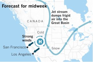
After a brief pause on Tuesday morning, strong, cold offshore winds are expected to return to California through Thursday.
“Wednesday’s and Thursday’s wind events have the potential of being the strongest of the season,” said Bill Patzert, a retired climatologist from the Jet Propulsion Laboratory in La Cañada Flintridge. “The worst of the punishing winds may be yet to come.”
The winds that tend to be the most intense are the cold Diablo and Santa Ana winds, Patzert said. That’s because cold air is heavy and it gains momentum as it plummets downslope from higher elevations toward lower pressure at sea level.
Frigid, dry arctic air from Canada is being deposited by the jet stream in a large area of high pressure in the Great Basin. This process is called advection, which means the transport of an atmospheric property by the wind.
Read the full story on LATimes.com.


