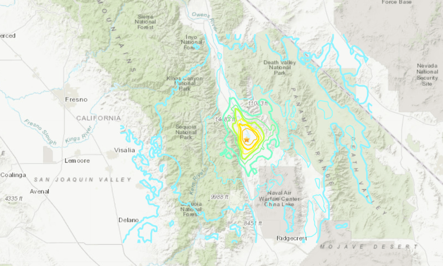
A magnitude 5.8 earthquake struck the Eastern Sierra region about 160 miles north of Los Angeles Wednesday morning, according to the U.S. Geological Survey.
USGS initially listed the magnitude as 6.1 and the epicenter at a GPS point about 20 miles southwest of Lone Pine in the Sierra Nevada range.
But the agency’s updated quake information downgraded the magnitude and indicated the epicenter was in the mostly dry Owens Lake bed, about 10 miles south-southeast of Lone Pine. The location is the center of the Owens Valley and the site of Los Angeles Department of Water and Power water facilities.
The Los Angeles Aqueduct, which sends water to the city of L.A.’s more than 4 million residents, is just a few miles from the epicenter. It wasn’t immediately clear if any equipment was damaged. The aqueduct, more than a century old, has survived many earthquakes.
The quake struck at 10:40 a.m. at a depth of around 3 miles.
Lone Pine, a town of about 2,000 residents, is known in part for the nearby filming of many classic western films. In 1872, Lone Pine was largely destroyed and many residents were killed in an earthquake that’s now believed to be a magnitude 7.4, one of the largest in recorded California history.
Wednesday’s temblor prompted reports of a rockslide and debris on two main roads that lead into the mountains, the Inyo County Sheriff’s Office said on Facebook. Local Sierra Wave radio reported little immediate damage, though a cleanup was in the works at a Lone Pine hardware store.
The quake was felt throughout Central California and parts of Southern California. The more than 10,000 respondents to USGS’s “Did You Feel It?” page indicated they experienced the temblor in Las Vegas, Reno and the San Francisco Bay Area as well.
Several aftershocks shook the area, including one with a 4.6 magnitude, according to USGS.
The quake struck in the same location as a magnitude 4.6 temblor earlier in the week, famed seismologist Lucy Jones said on Twitter. That earthquake is now considered a foreshock, she said.