Southland residents shouldn’t put their umbrellas away just yet as more rain is expected this week.
Meteorologists say there will be a slight break from wet weather on Thursday, but scattered showers are possible before rainfall picks back up on Friday and continues into Saturday. Showers could linger into Sunday.
Between 1 to 3 inches of total rainfall is expected once the storm is finished, according to KTLA meteorologist Vera Jimenez.
Higher elevations can expect around 2 to 2.5 inches of snow in areas over 7,000 feet.
Strong, gusty winds and slick roads will create dangerous driving conditions for commuters this week. Wind gusts from 30 to 50 miles per hour are expected with the strongest winds at higher elevations, according to NWS.

Rain storm system covering Southern California on the week of Nov. 15, 2023. (National Weather Service) 
Rain storm system covering Southern California on the week of Nov. 15, 2023. (National Weather Service) 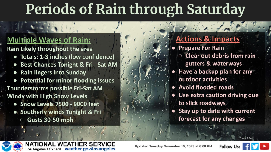
Rain storm system covering Southern California on the week of Nov. 15, 2023. (National Weather Service)
Showers and thunderstorms are expected across L.A. County, bringing frequent lightning and potential showers of small hail.
“The heavier cells are producing lightning,” NWS warns. “Be ready for sudden slowdowns on the roads. Lightning kills — When thunder roars, go indoors right away.”
“By Friday, the second piece of the trough will move into the region,” NWS said. “A low-pressure system continues to bring several waves of precipitation to the area into Saturday, with rain possibly lingering into Sunday.”
In the coastal and valley regions, between 0.75 inches to 1.5 inches is expected. Up to 1.5 inches is possible across the San Gabriel Mountains.
Residents across SoCal and especially in areas prone to flooding and mudslides are urged to prepare for the storm by:
-Clearing out debris from rain gutters and waterways
-Avoiding all flooded roads and areas with down trees or power lines
-Using extra caution when driving on slick roadways
-Rescheduling any planned outdoor activities
-Staying up-to-date with forecast changes
Those planning to visit the beach should avoid all water contact this week, especially near discharging storm drains, creeks, and rivers due to potentially higher bacteria levels, according to L.A. County Public Health officials.
Beach visitors should avoid touching any ocean runoff that may flow onto sand.
“Ocean and bay recreational waters can be contaminated with bacteria, chemicals, debris, trash, and other public health hazards from city streets and mountain areas after a rainfall,” health officials said. “Individuals who enter the water in these areas could become ill.”
The water advisory will be in effect until at least Saturday, Nov. 18. With possible extensions depending on rainfall.
Here are some of the highest rainfall totals through Wednesday:
- Crystal Lake (L.A. County) – 1.30
- Cogswell Dam (L.A. County) – 0.87
- West Fork Heliport (L.A. County) – 0.75
- Chilao South (L.A. County) – 0.75
- Ortega Hill (Ventura County – 0.69
- Inspiration Point (L.A. County) – 0.67
- San Gabriel Dam (L.A. County) – 0.67
- Mt. Olive High School (L.A. County) – 0.63
- Santa Anita Dam (L.A. County) – 0.63
- San Antonio Sierra PH (L.A. County) – 0.63
All rainfall totals can be viewed at NWS’ site. The most recent weather updates and forecasts can be viewed here. Track storms in real time with KTLA’s interactive radar map.