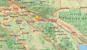
A magnitude-4.5 earthquake struck near Banning in Riverside County Wednesday morning, according to the U.S. Geological Survey.

The service initially said the temblor was a 4.8.
The quake occurred around 6:42 a.m., at a depth of 4.3 miles, and was just south of the San Bernardino National Forest and some 2.5 miles north of the 10 Freeway.
It was located about 4 miles north-northwest of Banning, 6 miles northeast of Beaumont and 9 miles east-southeast of Yucaipa.
Dan Switzer, of Banning, said the quake started out with light shaking and had a big jolt at the end.
It felt as if it moved right underneath his house, but it luckily didn’t cause any damage, he added.
Within minutes of the quake, dozens of KTLA viewers reported feeling shaking across L.A. and San Bernardino counties.
“If you’re very quiet,” people may have felt it 100, or even 200 miles away, but it was very unlikely to be felt from a distance of more than 50 miles, said USGS Seismologist Dr. Lucy Jones.
Despite the volume of people reporting they felt the temblor across Southern California, including one viewer in San Diego, a 4.5 is considered small, Jones added.
“A 4.5, if you’re near it, feels very strong, but there’s nothing in California that should be damaged at that level,” she said.
Cal Fire and the City of Riverside Fire Department received no immediate reports of injuries or damage, officials said.
There was a 5 to 10 percent chance of an aftershock or larger earthquake hitting the area in the coming week, Caltech seismologist Ellen Yu told the Los Angeles Times.
Wednesday’s quake occurred at a part of the San Andreas fault system that was so complex, the main fault at the surface had not been mapped, Jones said.
Previous temblors along the Banning part of the fault that were at or above a 4.5 magnitude included ones in 1988, 1992 and 2005.
The largest was a 5.9 in North Palm Springs on July 8, 1986.


