This is an archived article and the information in the article may be outdated. Please look at the time stamp on the story to see when it was last updated.
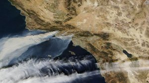
How massive are the wildfires torching Southern California? Smoke from the blazes is clearly visible from 438 miles above the Earth.

NASA’s Terra satellite captured this image Tuesday afternoon showing gray plumes of smoke from the fires, pushed by Santa Ana winds, drifting far out into the Pacific.
The largest plume, top left, is from the Thomas Fire, which has burned more than 50,000 acres in Ventura County. Smaller plumes from the Creek and Rye fires, closer to Los Angeles, also are visible. (Those puffy white streaks towards the bottom of the photo are clouds.)


